|
|||||||||
 |
 |
 |
 |
 |
 |
 |
|||
 |
 |
 |
 |
 |
 |
 |
 |
 |
 |
 |
 |
|
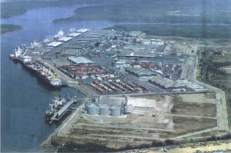
PORT OF GUAYAQUIL Guayaquil port is Ecuador’s main port handling 65% of total cargo of the country. Port of Guayaquil is located in the Muerto Creek, in front of the Trinitaria Island. Its coordinates are: Lat 02º 16' 51'' S Lon 79º 54' 49'' W The navigation access is done through the Morro channel, it begins with the first sea buoy located in front of Posorja, continues through the Salado Creek.and then through the Muerto Creek.
There are 47 buoys and 8 lights on the channel navigation route. Port of Guayaquil is tidal port type The channel longitude is 50 miles. The channel wide is 122 meters. The channel depth is 7.45 meters The turn basin is 400 yards Guayaquil counts with the Navy Ship Yard, additionally there are several small companies that do basic ship repairment. In Guayaquil there are all kind of supplies as water, bunkering, provisions, garbage removal, small repairing services, etc The access to the Guayaquil Port is done through the 25 de July Avenue, which is joined, through the Perimetral Highway to the six main roads that connect the city with the rest of the country. 1) Quito through Babahoyo 2) Quito through Daule 3) Manabi 4) Coast 5) Cuenca 6) Machala. There are 150.736 m2 of internal roads on the port, which the average wide of these roads are 20 meters. (Max: 32 meters, Min: 8 meters) No train or barge connections PORT CONDITIONS AND FACILITIES BERTH Container Berth General Berth a) General cargo berth - Two berths with a total length of 370 meters and a broad of the dock of 30 meters b) Bulk cargo berth - 1 berth for solid and liquid bulk cargo. (Total length 210 meters including 2 dolphins) c) Reefer Vessel berth - Three berths, with a total length of 555 linear meters and 30 meters of broad LENGHT AND DEPTH OF BERTH
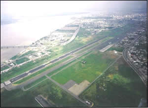
5. Berth Concession. No, actually the Guayaquil Port Authority administrates berths. 6. There is no container shore Gantry crane. Simon Bolivar Airport Airport Details Airport Code : GYE City : Guayaquil Longitude : 79° 52'
0" W
Simon Bolivar International Airport of Guayaquil was build on 1962 and is considered as air connection between Guayaquil and the entire coastal region. The SBIA is built over 170 hectares, including all fueling zones of 6,41 hectares. Current passengers terminal, all domestic and international are not sufficient to attend current passengers' demand and service levels had been diminished. International airlines use Guayaquil´s SBIA as an entrance airport as big planes of wide fuselage that cover long distances from Ecuador to North or South America or to Europe can not take off fully loaded from other national airports due to their altitude. It also has an operative classification of H24. With the extension done by the end of 2001, the runway has an extension of 2.790 meters of length and a capacity to attend 130.000 annual movements.
|